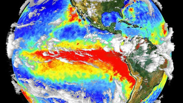
El Niño is an oscillation of the ocean-atmosphere system in the tropical Pacific which impacts weather patterns. It’s also known as the El Niño-Southern Oscillation (ENSO) cycle.
South American fishermen in the 1600s first christened El Niño, which means The Christ Child or The Little Boy, because the oscillation becomes active around Christmas time. Despite the name, no one waits for El Niño like it’s Santa Claus. Along the centuries, ENSO built a reputation as a home wrecker, destroyer of fisheries and even a killer. ENSO severely impacts global weather causing massive amounts of rainfall, powerful gusts of wind, floods or droughts, landslides, cyclones, and typhoons.
El Niño typically occurs in the Pacific but affects weather patterns globally
Since the 1930s, as a result of the pioneering work of Sir Gilbert Walker, climate scientists know El Niño occurs at the same time with the Southern Oscillation, which is a change in air pressure over the tropical Pacific Ocean.
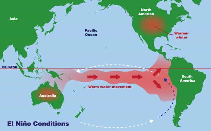
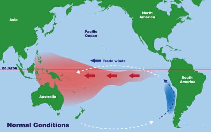
Near the equator, in the Pacific Ocean, the sun shines especially hot and the water at the surface is warmer. Eventually, coastal waters become warm enough to cause the atmospheric pressure above it to decrease. In a normal year, the trade winds blow westward, pushing warm water along the coast of Australian and New Guinea. During an El Nino event, however, strong winds push the warm waters eastward, moving it along the coast of South America until it ultimately pools in Indonesia and the Philippines.
This doesn’t happen all the time, though, since in some years the winds in fall and winter are too weak to move the warm water that far. Instead, the trade winds blow the warm waters towards South America where they split into north towards California and south towards Chile.
In the absence of an El Niño warm currents flow from east to west, due to the planet’s spin around its axis.
It’s important to note that ENSO is a coupled oscillation which means it can not occur unless interactions between the atmosphere and ocean are in sync. For instance, sometimes atmospheric patterns can shift in the tropical Pacific without the ocean fully responding, and vice versa.
[panel style=”panel-warning” title=”How often El Nino occurs” footer=””]Typically, an El Niño occurs every three to five years during the months of December and January, although it’s not that uncommon for it to happen every two years. ENSO episodes last 9 to 12 months, but some prolonged events may last for up to two years.[/panel]
El Niño effects
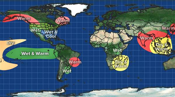
Weather is greatly influenced by the oceans’ surface temperatures. When the ocean is warm, such as during an El Nino, more clouds form leading to more rain. These clouds dump their excess water in South and Central America, as well as in the United States. Rainfall increases drastically in Ecuador and northern Peru, contributing to coastal flooding and erosion. Meanwhile, at the other end of the world, El Niño can cause droughts in Indonesia and Australia. These droughts threaten the region’s water supplies, as reservoirs dry and rivers carry less water, severely impacting agriculture yield. An El Niño might also trigger odd weather events like making lakes out of deserts overnight or turning rainforests into charcoal.
A severe El Niño event amplifies the western Pacific jet stream and shifts it to the east, which is why in some odd years you’ll see freak winter storms over California and the southern United States, along with floods and landslides.
El Niño lowers the probability of hurricanes forming in the Atlantic but increases the chance of cyclones and typhoons in the Pacific. Strong El Niño events also contribute to weaker monsoons in India Southeast Asia.
The El Niño events of 1982-83 and 1997-98 were the most intense of the 20th century. During the 1982-83 event, sea surface temperatures in the eastern tropical Pacific were 9-18° F above normal and the ensuing onslaught caused $45 billion in damage.
The most recent El Niño, that of winter of 2015, was one of the strongest recorded. Record smashing temperatures hit Thailand, Laos, and Cambodia. In Malaysia, lakes dried up and vegetables withered while weak monsoons and killer heatwaves left India barren.
El Niño forecast
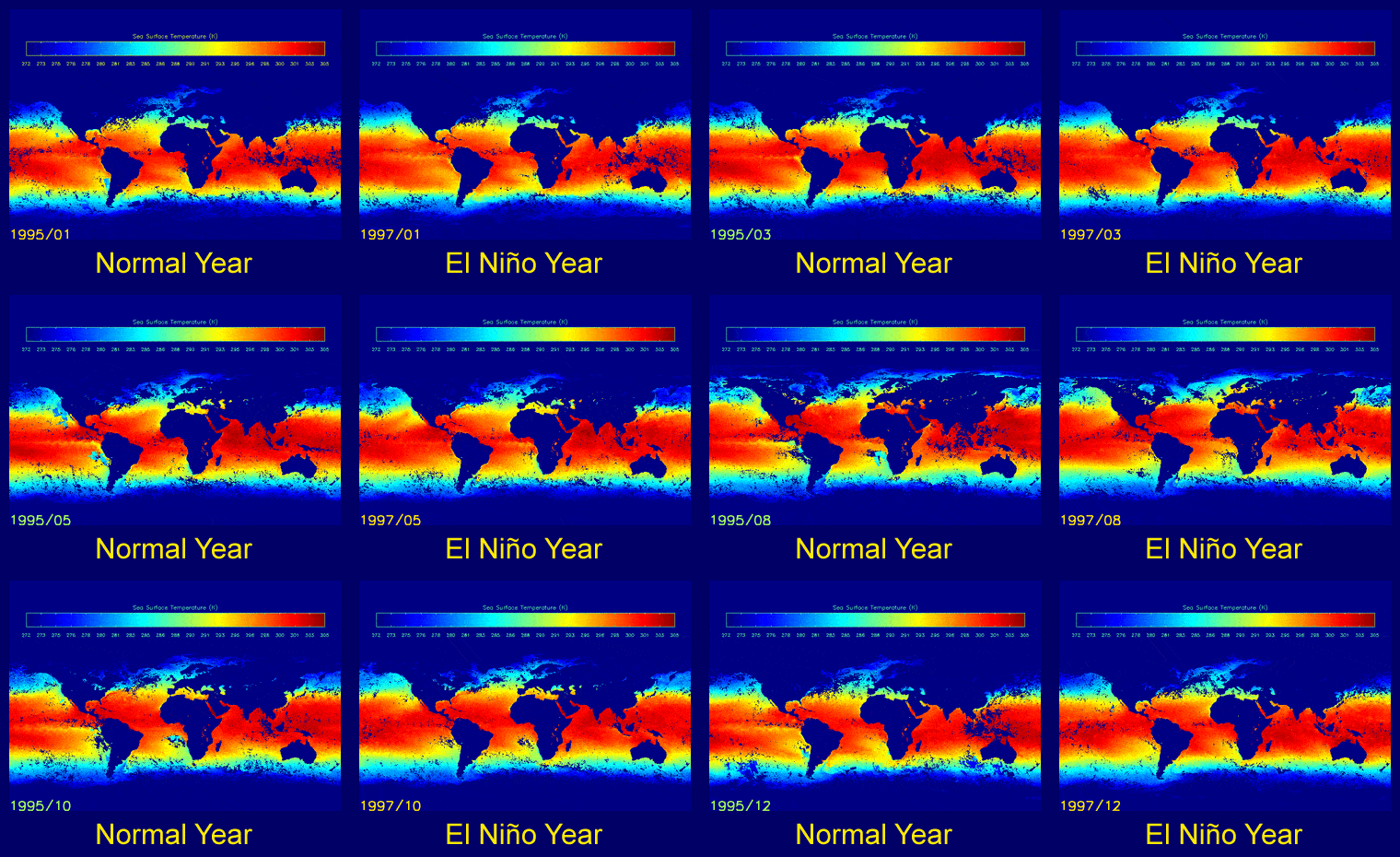
We don’t currently have the right tools to predict when an El Niño event will happen or how strong it will hit, but we have some pretty good hints. For instance, we know that the oscillation is triggered by changes in pressure and temperature, so these parameters are carefully monitored on a daily basis.
Prior to the 1980s measurements of sea surface temperature were derived from instruments on shorelines, ships, and buoys. Since then, scientists rely on satellite observations because these are more reliable and can cover the whole planet. When the ocean gets warmer, the water expands and sea level rises slightly. The Jason-1 and Jason-2 satellites launched in 2001 and 2008, respectively, are now the go-to instruments for climate scientists because they employ the most sensitive altimeter onboard.
To make things easier, climatologists have developed the Oceanic Nino Index (ONI) whose values correspond to deviations from normal sea temperatures. An El Niño event is forecasted with confidence if sea surface temperatures rise by more than 0.9 degrees Fahrenheit for at least five consecutive three-month seasons. The bigger the temperature deviation, the more powerful the impact El Niño will have on weather and climate. For instance, a weak El Niño raises sea surface temperatures by 4 to 5 degrees F and only moderately affects the world’s climate, but if the temperature rises by 14 to 18 degrees F, the consequences can be very serious.
El Niño flavors
El Niño is one of the most recognizable climatic events, not least because of the tremendous influence it has on the planet’s weather. There is still a work that needs to be done before we can predict El Niños further out and understand why some effects only show up sometimes. Knowing when and where it will strike will help us prepare for the impacts and make El Niño years less costly to society.


