ZME Science
No Result
View All Result
ZME Science
No Result
View All Result
ZME Science

Home → Science → News

New weather satellite offers mind-blowing views of our planet

The level of detail is just impressive.

Fermin KoopbyFermin Koop
May 4, 2023 - Updated on May 5, 2023
in News
A A
Edited and reviewed by Mihai Andrei
Share on FacebookShare on TwitterSubmit to Reddit

Europe’s new weather satellite, the Meteosat Third Generation Imager (MTG-I1), delivered its first view of Earth, revealing weather conditions over Europe, Africa and the Atlantic in impressive detail. Launched in December, the MTG-I1 is the first of a new generation of satellites that is expected to improve weather forecasting.

The Earth seen from space
Image credits: EUMESTAT.

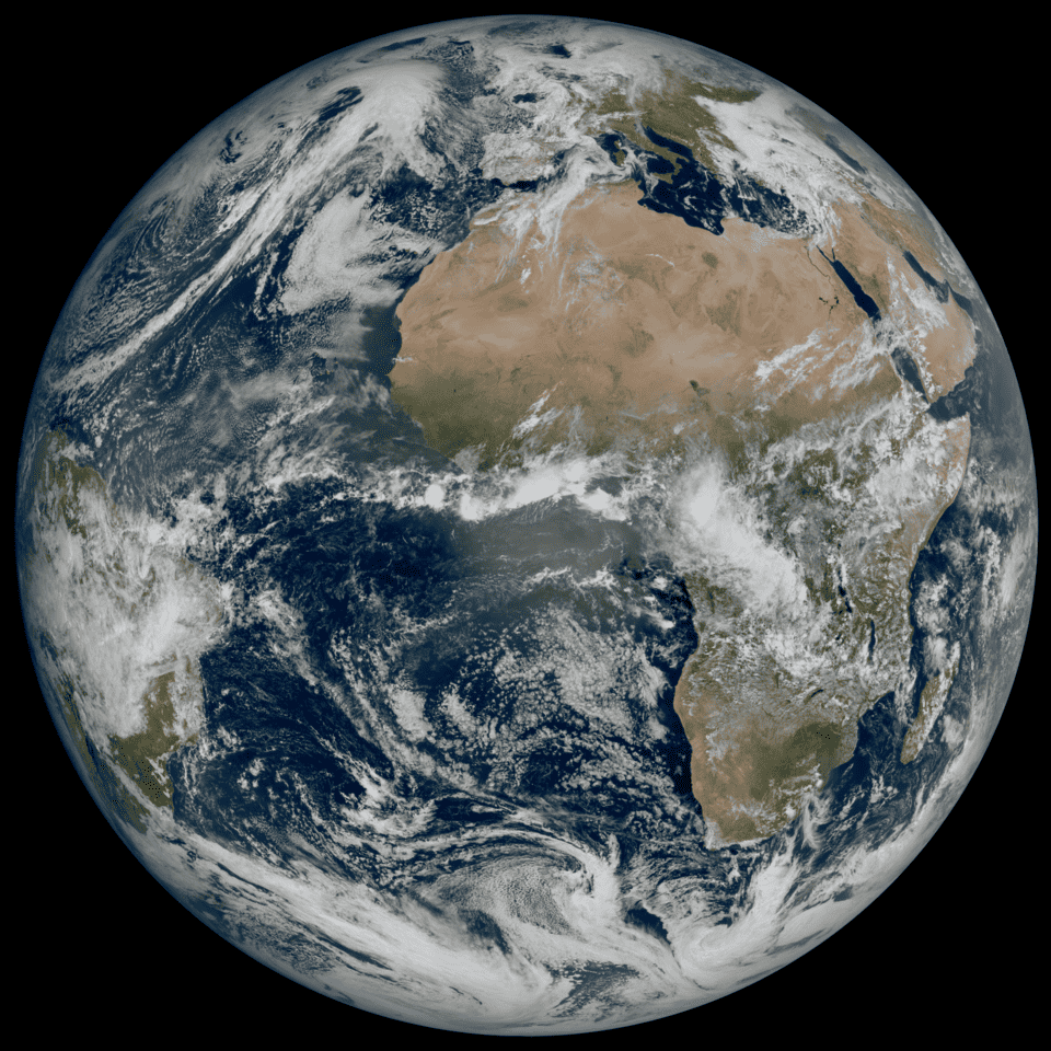
The wide image of Earth, captured on March 18, 2023, shows most of Northern and Western Europe and Scandinavia blanketed in clouds, with clear skies over Italy and the Western Balkans. Many of the details in this and the other images aren’t clearly visible, or not visible at all, with the instruments on second-generation satellites.

“The level of detail MTG-I1’s image reveals, unachievable over Europe and Africa from a geostationary orbit until now, will give us a greater understanding of our planet and the weather systems that shape it,” Simonetta Cheli, the Director of Earth Observation programs at the European Space Agency (ESA), said in a media statement.

A breakthrough for weather observation

Since 1977, Europe has had its own meteorological spacecraft stationed above the planet. Meteosat-12 is the third iteration in this series and is currently positioned in a stationary location, monitoring Europe, the Middle East, and Africa continuously. It can take one picture every 10 minutes – five minutes faster than the previous version.

The satellite can also capture images in 16 wavelengths of light, four more than the second generation. Thanks to the additional bands of light, it can produce true color images, which closely resemble what the human eye might perceive if viewing Earth from the same location. Hence the impressive first batch of photos it has just sent.

Image credits: EUMESTAT.

Details such as the snow cover of the Alps, sediment in the water along the coast of Italy, and cloud vortices over the Canary Islands are visible in the images. There’s also a greater level of detail of cloud structures at high altitudes. This is expected to allow weather forecasters to monitor the development of severe weather more accurately.

RelatedPosts

Planet Earth got hold of a new companion, and it’s here to stay
NASA satellite crashes deal serious blow to geoscience efforts
Japan start-up planning to sell “shooting stars on demand” launched their first satellite
We can now track ocean microplastics from space, by looking at how winds and water interact

“That additional detail from the higher resolution imagery, coupled with the fact that images will be produced more frequently, means forecasters will be able to more accurately and rapidly detect and predict severe weather events,” Phil Evans, Director General at Eumetsat, the European agency for monitoring weather, said in a statement.

MTG-I1 is the first of six satellites that form the full MTG system, which will provide data for short-term and early detection of potential extreme weather events. When fully operational, the mission will comprise two MTG-I satellites and one MTG Sounding (MTG-S) satellite. The latter will carry an UV spectrometer and an infrared sounder.

The overall cost of the mission is expected to be about 4.3 billion. This seems like a lot, but having a good meteorological system can actually save a ton of money in infrastructure damage. And this also becomes more necessary as the climate crisis kicks in. Extreme weather events are expected to become more severe and intense in the years to come.

Tags: satellite

ShareTweetShare
Fermin Koop

Fermin Koop

Fermin Koop is a reporter from Buenos Aires, Argentina. He holds an MSc from Reading University (UK) on Environment and Development and is specialized in environment and climate change news.

Related Posts

Mapping vertical land motion across the New York City area, researchers found the land sinking (indicated in blue) by about 0.06 inches (1.6 millimeters) per year on average. They also detected modest uplift (shown in red) in Queens and Brooklyn. White dotted lines indicate county/borough borders. Credit: NASA/JPL-Caltech/Rutgers University.
Geology

Satellite data shows New York City is still sinking — and so are many big US cities

byFermin Koop
3 days ago
News

Astronomers Warn That Satellite Mega-Constellations Could Steal the Night Sky Forever

byMihai Andrei
3 weeks ago
Climate

White House Wants to Destroy NASA Satellites Tracking Climate Change and Plant Health

byMihai Andrei
1 month ago
Climate

Climate Change Unleashed a Hidden Wave That Triggered a Planetary Tremor

byMihai Andrei
3 months ago

Recent news

Biggest Modern Excavation in Tower of London Unearths the Stories of the Forgotten Inhabitants

September 17, 2025

Millions Of Users Are Turning To AI Jesus For Guidance And Experts Warn It Could Be Dangerous

September 17, 2025

Can Giant Airbags Make Plane Crashes Survivable? Two Engineers Think So

September 17, 2025
  • About
  • Advertise
  • Editorial Policy
  • Privacy Policy and Terms of Use
  • How we review products
  • Contact

© 2007-2025 ZME Science - Not exactly rocket science. All Rights Reserved.

No Result
View All Result
  • Science News
  • Environment
  • Health
  • Space
  • Future
  • Features
    • Natural Sciences
    • Physics
      • Matter and Energy
      • Quantum Mechanics
      • Thermodynamics
    • Chemistry
      • Periodic Table
      • Applied Chemistry
      • Materials
      • Physical Chemistry
    • Biology
      • Anatomy
      • Biochemistry
      • Ecology
      • Genetics
      • Microbiology
      • Plants and Fungi
    • Geology and Paleontology
      • Planet Earth
      • Earth Dynamics
      • Rocks and Minerals
      • Volcanoes
      • Dinosaurs
      • Fossils
    • Animals
      • Mammals
      • Birds
      • Fish
      • Amphibians
      • Reptiles
      • Invertebrates
      • Pets
      • Conservation
      • Animal facts
    • Climate and Weather
      • Climate change
      • Weather and atmosphere
    • Health
      • Drugs
      • Diseases and Conditions
      • Human Body
      • Mind and Brain
      • Food and Nutrition
      • Wellness
    • History and Humanities
      • Anthropology
      • Archaeology
      • History
      • Economics
      • People
      • Sociology
    • Space & Astronomy
      • The Solar System
      • Sun
      • The Moon
      • Planets
      • Asteroids, meteors & comets
      • Astronomy
      • Astrophysics
      • Cosmology
      • Exoplanets & Alien Life
      • Spaceflight and Exploration
    • Technology
      • Computer Science & IT
      • Engineering
      • Inventions
      • Sustainability
      • Renewable Energy
      • Green Living
    • Culture
    • Resources
  • Videos
  • Reviews
  • About Us
    • About
    • The Team
    • Advertise
    • Contribute
    • Editorial policy
    • Privacy Policy
    • Contact

© 2007-2025 ZME Science - Not exactly rocket science. All Rights Reserved.