Four years ago this island didn't exist. Now it's full of vegetation and "mystery mud"
Our planet really is alive.
In 2015, a new island formed due to an eruption of an underwater volcano. Now, one NASA scientist has visited it.
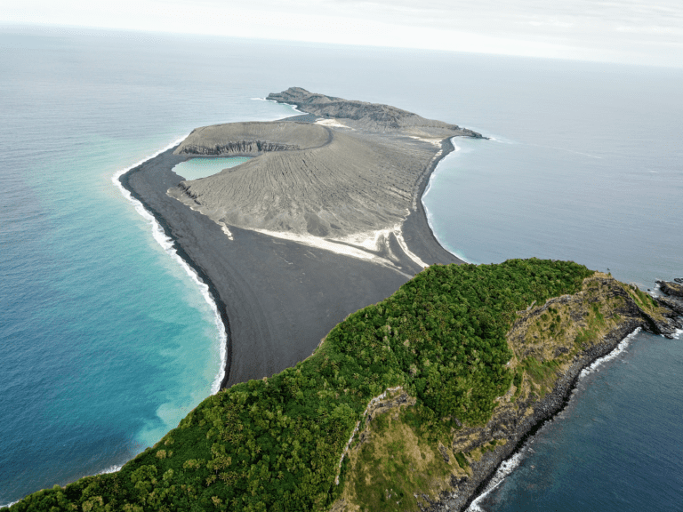
The three-year-old volcanic island (center) as seen from the SEA drone. The island remains officially unnamed, but it is generally referred to as Hunga Tonga-Hunga Ha’apai. Credit: Sea Education Association / SEA Semester / NASA.
“There’s no map of the new land,” said Dan Slayback of NASA’s Goddard Space Flight Center in Greenbelt, Maryland.
Nestled between two other volcanic islands, the newly formed landmass was mostly known from satellite. Even so, it taught geologists quite a bit about how islands can form — but there’s only so much you can learn from satellite. Right off the bat, it was clear that the island was full of surprises.
First off, it wasn’t the flat landscape the team was expecting.
“Immediately I kind of noticed it wasn’t quite as flat as it seems from satellite,” Slayback comments. “It’s pretty flat, but there’s still some gradients and the gravels have formed some cool patterns from the wave action.”
The surprises just kept on coming. The team came across something no one was expecting: mud. How this mud came to be on a volcanic island is anyone’s guess at this point.
“there’s clay washing out of the cone. In the satellite images, you see this light-colored material. It’s mud, this light-colored clay mud. It’s very sticky. So even though we’d seen it we didn’t really know what it was, and I’m still a little baffled of where it’s coming from. Because it’s not ash.”
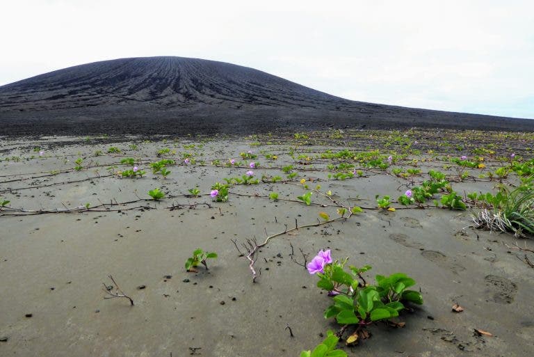
Vegetation taking root on the flat isthmus of Hunga Tonga-Hunga Ha’apai. The volcanic cone is in the background. Credit: Dan Slayback / NASA.
As they were walking across the island, they also noticed the vegetation, as well as the fauna. The first animal they saw was a barn owl — which, while unexpected, isn’t all that surprising, as barn owls are found all over the world. How the owl got there, however, remains a mystery.
They also came across hundreds of nesting sooty terns that had taken shelter in the deep gullies etched into the cliffs surrounding the crater lake.
Slayback also took samples of rocks — like any respectable Earth scientist would. He harvested several small samples (with Tongan permission) for mineral analysis back at Goddard’s Non Destructive Evaluation Lab.
But perhaps even more importantly, he took exact measurements of the island’s position and elevation.
“The point is to try to take the satellite imagery and tie it to a known reference point, particularly the vertical elevation. The software that generates Digital Elevation Models (a 3D map) from stereo imagery is using a geoid model, and it’s not great in remote places like this. So if you were standing there with your GPS and you’re looking at the ocean at sea level and it’s telling you you’re at four meters elevation, you’re like, But I’m not! I’m at sea level,” he said. So he wanted to find a reasonable adjustment to the geoid model for local mean sea level.
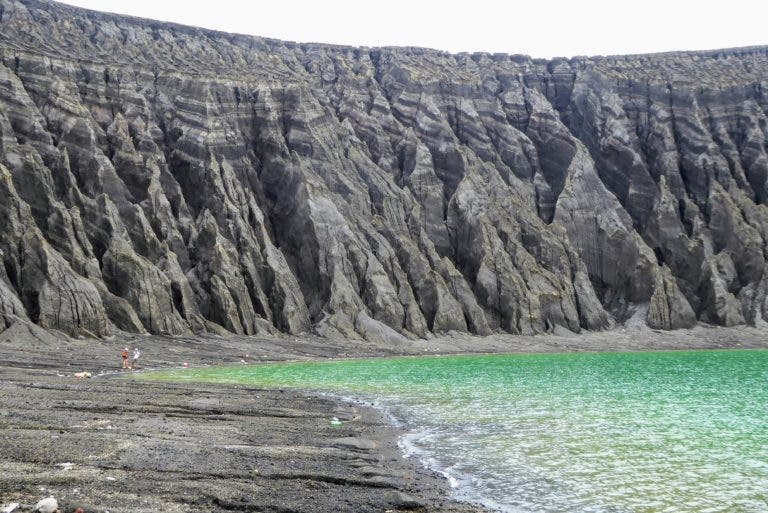
The cliffs of the crater lake are etched with erosion gullies, which are getting bigger. Image credits: Dan Slayback / NASA.
So he used two GPS systems: one which was fixed, as a reference, and one which was mobile. With this, he was able to take 150 measurements, obtaining a precision of under 10 centimeters.
He found that the island is quickly eroding, making for an excellent time-lapse geological study.
“It really surprised me how valuable it was to be there in person for some of this. It just really makes it obvious to you what is going on with the landscape,” Dan said. One feature that was eye-opening in person was the deep erosional gullies that run down the side of the volcanic cone. “The island is eroding by rainfall much more quickly than I’d imagined. We were focused on the erosion on the south coast where the waves are crashing down, which is going on. It’s just that the whole island is going down, too. It’s another aspect that’s made very clear when you’re standing in front of these huge erosion gullies. Okay, this wasn’t here three years ago, and now it’s two meters deep.”
The data is currently being processed and analyzed, and Slayback hopes to return next year to find out even more answers about the island.


