Satellite captures how San Andreas plate is moving
The two tectonic plates in San Andreas are gliding past each other. Now, we can see them from high in the sky.
You can’t predict an earthquake. But you can get some information about what’s happening through seismic activity. This can be done with very precise GPS trackers left in place — but as a new study showcases, it can also be done with satellite radars.
Tectonic woes
Our planet’s surface (the crust) isn’t one continuous shell. It’s cracked into several pieces we call ‘tectonic plates’. The tectonic plates move all around, and when they interact with one another, they can create serious earthquakes. This is exactly what’s happening at the San Andreas fault.
Sometimes, tectonic plates bump into one another; other times, they move away from one another. In the case of San Andreas, the Pacific and North American plates brush past each other. As they slide, they create friction and tension builds up. When this tension is released — bang, you get an earthquake. This is called a transform fault.
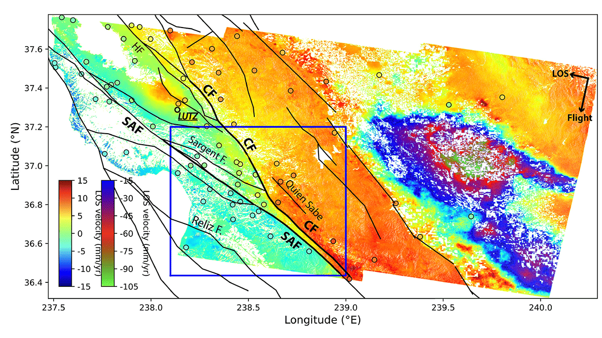
In this particular study, researchers focused on the Calaveras Fault, which branches from San Andreas. Both faults are slipping at variable rates. “It is unusual to observe two rapidly creeping faults that are so close to each other,” the study authors led by Yuexin Li note. Li is a postdoctoral researcher at the Berkeley Seismology Laboratory.
The researchers used InSAR (Interferometric Synthetic Aperture Radar) — a technique for mapping ground deformation using radar images of the Earth’s surface. These images can be gathered from satellites. The method uses two or more synthetic aperture radar (SAR) images to generate maps of surface deformation or digital elevation models, providing a precise measurement of changes in the Earth’s surface.
Radar satellites
The method starts with a satellite equipped with a SAR instrument that sends a radar signal toward the Earth’s surface. This signal then bounces back to the satellite and is recorded. This process is repeated at different times to obtain multiple images of the same area.
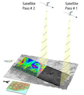
The satellite records various parameters of the radar, including the phase of the wave. The phase difference between the radar signals from two images is then calculated. This phase difference is used to create an interferogram, which is a kind of map showing the relative motion of the ground between the times the two images were taken.
Li and colleagues used a high-resolution time series of radar images acquired by the Sentinel-1 satellites over a five-year period, from 2015 to 2020. They created a map of small movements, on the scale of millimeters per year, showing which areas around the faults move and which forces drive them. They also show that the method can identify periods when earthquakes are intensifying or reducing.
“We find that the fault creep rate is to first order controlled by fault geometry and regional tectonics. In addition, we observe a slowdown in fault creep during 2016–2018 on the SAF, confirmed by analysis of clusters of small earthquakes and repeating earthquakes that have nearly identical seismic waveforms,” the authors note.
“This may indicate that the SAF is extremely sensitive to small loading perturbations. Our study shows remote sensing techniques are capable of monitoring subtle large-scale ground deformation with good spatial and temporal accuracy, which is important for monitoring fault slip behaviors and assessing seismic hazard.”
The use of InSAR has provided valuable insights into the complex dynamics of the San Andreas and Calaveras faults, revealing the subtle, millimeter-scale movements that occur over time. These findings underscore the sensitivity of these faults to even minor perturbations, highlighting the need for continuous monitoring to better understand and potentially mitigate the seismic risks they pose.
Ultimately, this shows that satellite data can be an excellent tool to monitor seismic activity which in turn, can help us better prepare for earthquakes.
It’s a reminder thatm while we may not be able to predict earthquakes, we are continually improving our ability to monitor and understand the forces that cause them. As we refine these remote sensing techniques, we can hope to gain a more detailed picture of our planet’s seismic activity, contributing to our ongoing efforts to safeguard communities living in earthquake-prone regions.
Journal Reference: Li et al (2023). Spatiotemporal Variations of Surface Deformation, Shallow Creep Rate, and Slip Partitioning Between the San Andreas and Southern Calaveras Fault. JGR Solid Earth.