Geologists are close to cracking the mystery of one of the biggest earthquakes in American modern history – the 1872 North Cascades event. Now, over one century later, they believe they have finally found the origin of the earthquake.
An ancient mysterey
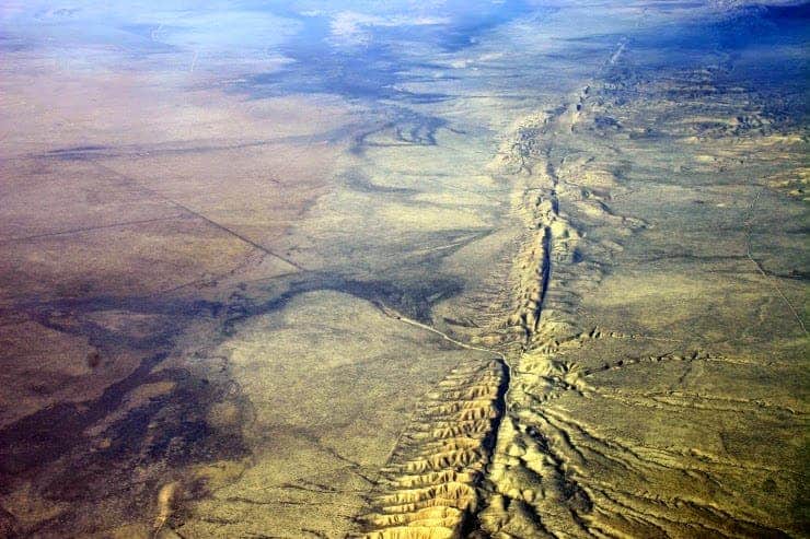
Current research points to a newly discovered fault near the town of Entiat in Chelan County, Wash. This adds more evidence to the idea that central and eastern Washington are much more earthquake prone than previously thought. This research will not only elucidate a seismological mystery, but it might also refine our understanding of the seismic risks the Washington area is subjected to.
“For more than four decades, people have been guessing where the 1872 earthquake was,” said Craig Weaver, regional chief of the U.S. Geological Survey’s earthquake programs. “To be able to finally pinpoint this thing on a map would be really important in helping us get the seismic hazard assessment correct in that part of the state.”
The earthquake took place on December 15 1872, at 5:40 a.m. local time in northern Washington state. Ulysses S. Grant was president in those days. Witnesses from Washington reported cracking chimneys, trees popping up from the ground and fissures splitting the ground. But the earthquake was felt significantly in seven states, with windows cracking as far as Victoria, British Columbia. According to this research, that happened because the epicenter was actually close to British Columbia, not far from Vancouver.
The magnitude of the earthquake is still debated, with guesses ranging between 6.5 and 7.5 – a huge difference considering that the magnitude is a logarithmic scale (a 7.5 earthquake has 10 times more energy than a 6.5 earthquake). However, one thing’s for sure – it was a big earthquake.
“No matter how you define it, that’s a big earthquake,” said USGS researcher Brian Sherrod, who led the modern-day hunt for the quake’s source. “It was felt from Montana and British Columbia down into Oregon and Northern California.”
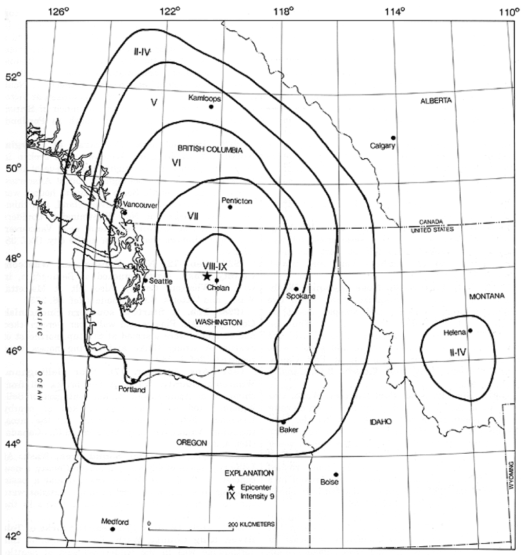
Pinpointing the epicenter of the earthquake become even more important in the 1970s, when talks about a nuclear plant emerged in the area; naturally, nobody would want to place it close to the epicenter, where there is a considerable seismic hazard… but where is the epicenter? The result was a series of reports that put the epicenter back and forth across the Cascades but there was no clear answer. A Seattle politician called it “the earthquake that wouldn’t stay put”. No one was able to find the fault… at least until now.
To understand the Earth, look to the sky
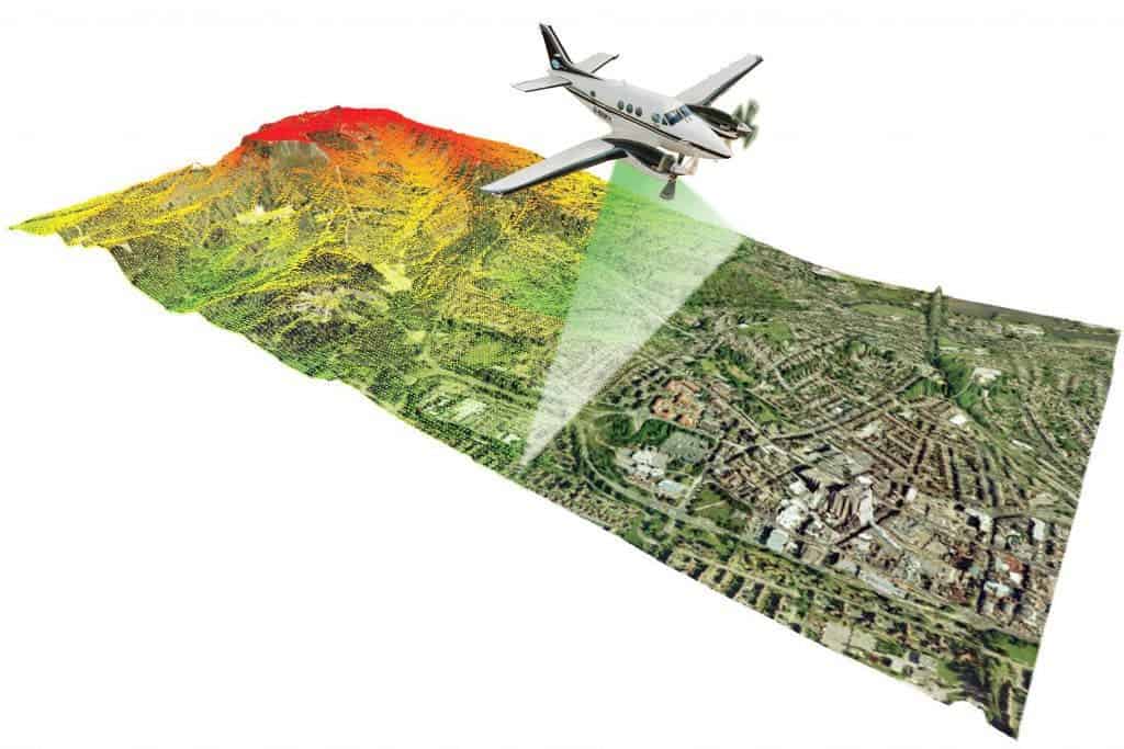
Six years ago, Sherrod started using a new tool, called LiDAR. Lidar (also written LIDAR or LiDAR) is a remote sensing technology that measures distance by illuminating a target with a laser and analyzing the reflected light. Basically, the tool can offer some information on the ground based on how light reflects off of it. In this way, scientists were able to visually strip out the vegetation and create detailed topographic maps by beaminglaser pulses from an airplane and analyzing the way the signals bounce back.
The first images, taken in 2008 didn’t reveal much, so the USGS commissioned another data acquisition campaign in 2013, and things started to become much clearer then.
“When I looked at those, it just popped out,” Sherrod said in late October as he led a team of geologists down a fire-blackened hillside in the Okanogan-Wenatchee National Forest and into a small valley that drains into the Columbia River. He located what is most likely the culprit for the 1872 earthquake.
After making the Lidar maps, he also got his hands dirty and did some field exploration – what he found confirmed the existence of a big fault. Now only one question remains – did the fault expose itself during the 1872 earthquake, or during some other more recent earthquake? For geologist Jim Miller, of the consulting firm GeoEngineers there is little doubt – the fault is like a smoking gun.
“The information I’ve got right now gets me to the 98 percent confidence level,” said Miller, who helped Sherrod excavate the trenches and examine the scarp. A fault scarp is a small step on the ground surface where one side of a fault has moved vertically with respect to another.
The team also collected samples of volcanic ash, coal and wood for radiodating – to establish the age of the most recent earthquake and get more information about how the fault might snap in the future. If the epicenter of the 1872 earthquake is confirmed to be where geologists have now pinpointed it, it will have big implications for future engineering projects, like nuclear facilities or water dams. But for Sherrod and his team, there is also a different satisfaction – like crime scene investigators, they have solved a geological mystery.
“For more than four decades, people have been guessing where the 1872 earthquake was. To be able to finally pinpoint this thing on a map would be really important in helping us get the seismic hazard assessment correct in that part of the state. “For more than four decades, people have been guessing where the 1872 earthquake was. To be able to finally pinpoint this thing on a map would be really important in helping us get the seismic hazard assessment correct in that part of the state. ”


