The sun and the ocean — a perfect combination for a summer vacation. But while we may enjoy dry, sunny, and peaceful coastlines, this idyllic scenario can change at any moment. In fact, the combination of sun and water often makes for very un-peaceful circumstances.
Some of the most extreme weather phenomena come from this combination: things like hurricanes and typhoons. But how do these form, and what’s the difference between one and the other?

Cyclones, typhoons, and hurricanes
First of all, let us settle the confusion among the three terms: cyclones, typhoons, and hurricanes. All terms refer to an intensified union of clouds and thunderstorms rotating above tropical and subtropical waters. They’re pretty much the same thing — the only real difference lies in the location of where the storm is formed.
Hurricanes are storms formed over the North Atlantic Ocean and Northeast Pacific whereas cyclones develop over the South Pacific and Indian Ocean. “Typhoon” is used when this weather disturbance is formed over the Northwest Pacific Ocean.
To put it simply, all three things refer to the same phenomenon, they’re just local terms pretty much. Scientifically, experts use the term “tropical cyclone” to collectively refer to all three — because they’re all cyclones that happen around the tropics.
A recipe for a storm
Storms and cyclones can vary in intensity dramatically. Over the years, mankind has experienced the wrath of all sorts of storms, but no matter how strong they are, all storms are a product of a single recipe.
Tropical cyclones usually develop during the late summer when the temperature difference between air and water is at its greatest. It starts out with storm clouds forming when ocean surface temperatures reach above 27 degrees Celsius (80F).
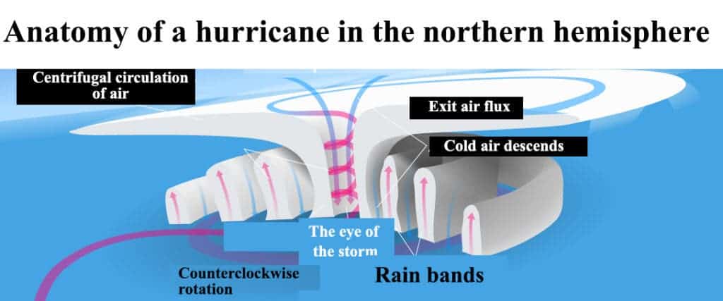
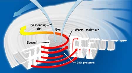
The warm waters provide the fuel the storm needs to become a hurricane — think of tropical cyclones as giant engines that use warm air as fuel. The increasing ocean temperature heats up the surrounding air, and as the air heats up, it becomes lighter and rises. This high temperature also encourages evaporation.
As this air rises away from the surface, it leaves behind an area with less air – fewer gas molecules – which creates a low-pressure zone. Air from the surrounding areas with higher pressure then migrates into this low-pressure zone to fill the pressure gap. But, this new air also becomes warm and moist, and rises, repeating the process again and again, creating a flux of air where hot air rises, cools as it moves out away from the heat source, then falls again as cold air.

Another key ingredient is having minimal differences in wind speed from the surface to high in the sky. This is necessary to maintain stable air movement as dramatic change can rip storms apart. If all these elements combine in the “right” way, you can end up with a tropical depression which may or may not develop into a storm — only when the rotating winds reach a certain speed is it technically called a storm.

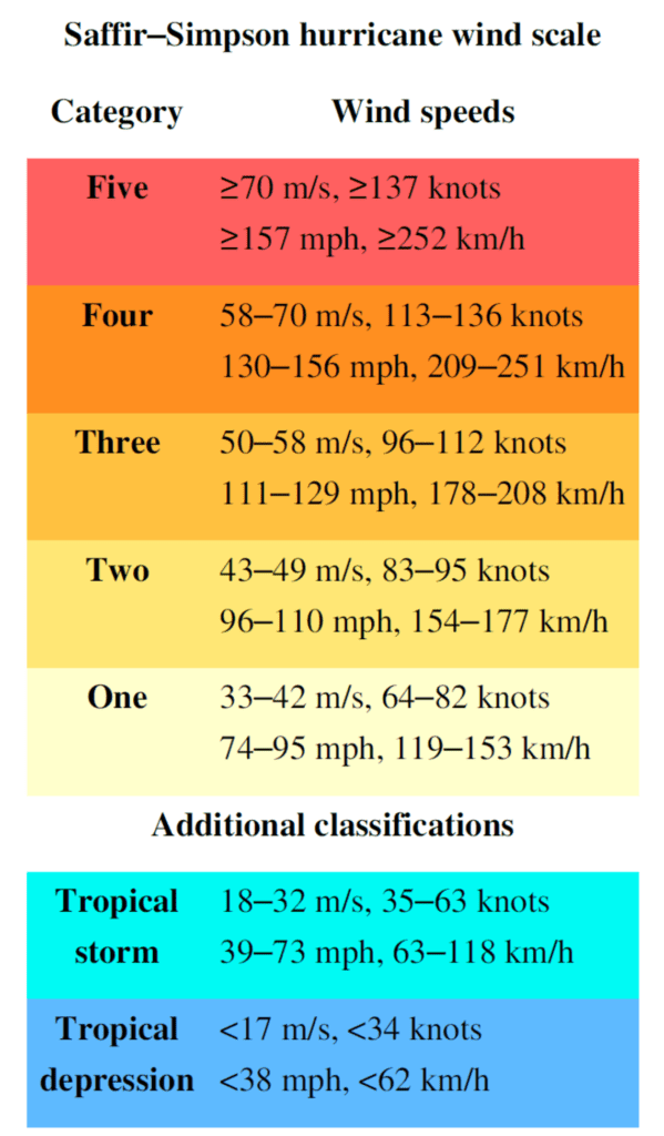
Initially, a tropical depression is characterized by the presence of thunderstorm winds of 62 km/hour (39 mph). It will only be “upgraded” into a tropical cyclone if it reaches wind speeds of 179.6 km/hour (111 miles). This is much faster than any highway speed limit.
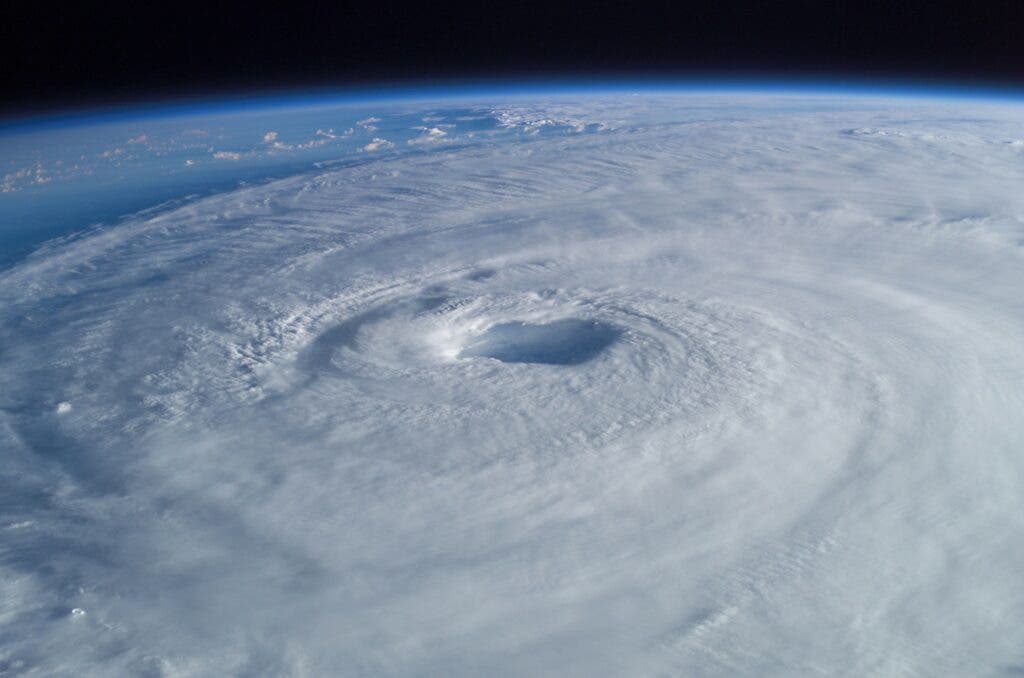
Furthermore, the presence of a clear eye is also notable as this is an indicator that it has formed a closed circulation pattern, a distinct characteristic of tropical cyclones.
Deadliest storms
Storms are classified into different categories based on their strength which is measured by their wind speeds. There are different scales for hurricanes, typhoons and cyclones. The US, for instance, uses the Saffir-Simpson Hurricane Wind Scale which has five categories. Category 1 has sustained winds of 74-95 mph (119-153 km/h) that are already capable of producing some damage to property. Meanwhile, on the other end of the scale is the catastrophic Category 5 hurricane that has sustained winds reaching 157 mph or higher (252 km/h or higher). This hurricane is so strong that it can most likely destroy concrete structures, trees, and electrical posts.

One of the most devastating hurricanes to ever hit the US was Hurricane Ida which made landfall in Louisiana in 2021. It was nearly a category 5 hurricane with 150 mph sustained winds. It caused 115 fatalities and damage costing up to $75.25 billion. In 2017, Hurricane Maria hit Dominica with sustained wind speeds of around 160 mph and peak winds of 175 mph (280 km/h).
On the other side of the world, typhoon Haiyan (local name Yolanda), was one of the strongest and deadliest typhoons ever formed with wind speeds reaching up to 315 km/h (195 mph) (1 minute sustained winds). It mercilessly ravaged the Philippines in 2013 leaving more than 7,300 people dead or missing.
In 1970, a devastating storm hit Bangladesh, killing an estimated 300,000 people. Bangladesh is, in fact, probably the country worst affected by severe storms, having also experienced the 2nd, 5th, 9th and 10th worst storms on record (in terms of lives lost).
Climate change enters the scene

Storms happen with or without climate change. Big storms also happen with or without climate change. But the intensity and frequency of these storms is linked to climate change. Science has consistently shown that climate heating is causing more and stronger storms, and we’re already seeing the effects.
In other words, we’re to blame for the stronger storms. Strong scientific consensus points out that anthropogenic greenhouse gas emissions are causing sea surface temperatures to increase hence there is more energy for storm formation. Additionally, these stronger typhoons have more moisture, track differently, and move faster.
“There is strong scientific consensus that anthropogenic greenhouse gas emissions are causing climate change and that this is contributing to stronger typhoons due to higher sea surface temperatures and higher subsurface sea temperatures, which remove the natural buffer on typhoon strength occasioned when cold water up wells from below the ocean’s surface,” a recent study notes. “These stronger typhoons carry more moisture, track differently, move faster and will be aggravated by sea level rise, one of the most certain consequences of climate change.”
With these detrimental effects, measures to mitigate the effects of climate change (especially in the face of extreme storms) must be taken. If the globe warms by 2 degrees Celsius, we’ll very likely experience more Category 4 or 5 tropical cyclones that have more damaging winds and extreme rainfall.


