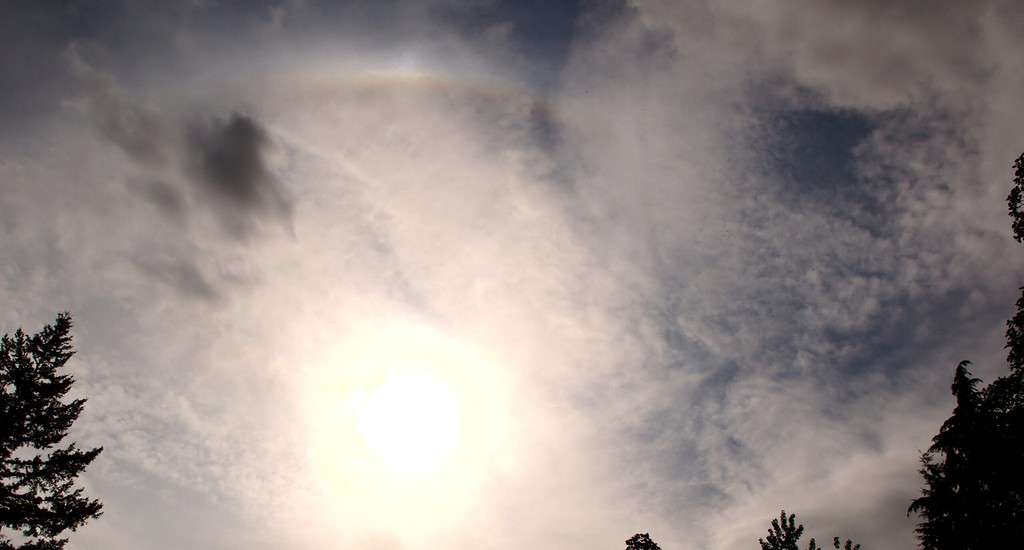
While they might not have the attention-grabbing power of their more flamboyant cousins, such as cumulonimbus or cumulus clouds, cirrostratus clouds have a unique charm of their own. In this guide, we’ll demystify these high-altitude wanderers. We’ll explore what they are, how they form, the weather they predict, and their subtypes, and answer some frequently asked questions about them.
What are Cirrostratus Clouds?
Cirrostratus clouds are thin, white clouds that cover the sky like a translucent blanket. Now, you might not notice them right away, as they’re often faint or see-through, but if you pay close attention, you’ll find that they often give the sky a slight, milky appearance.
These clouds belong to the high cloud group (5,000-13,000m), so you’re looking up quite a distance to see them. They’re composed mostly of ice crystals, which can create beautiful optical phenomena like halos. If you’ve ever seen a ring around the sun or the moon, there’s a good chance you were looking at a cirrostratus cloud.
How do Cirrostratus Clouds Form?

Clouds form when moist air rises, expands, and cools in the atmosphere. In the case of cirrostratus clouds, this process occurs at high altitudes, where the air is chillier. These conditions favour the formation of ice crystals, which come together to form these high, thin clouds.
Identifying Cirrostratus Clouds
Identifying cloud types can be a fun and rewarding activity, a bit like a sky-high game of I Spy. Here are some key characteristics to look out for when trying to identify cirrostratus clouds:
1. Coverage: Cirrostratus clouds often cover the entire sky. Unlike other types of clouds that can appear in more isolated patches, cirrostratus clouds form a continuous, thin layer across the sky.
2. Transparency: Despite covering the sky, cirrostratus clouds are so thin that they often appear nearly transparent. The sun or moon can be seen quite clearly through them, giving them a soft, diffused glow. If the sun is shining directly behind these clouds, you may notice that the light appears to be slightly dimmed, as if through frosted glass.
3. Halo Effect: One of the most unique characteristics of cirrostratus clouds is the halo effect they can produce around the sun or moon. This occurs when the sunlight or moonlight refracts, or bends, as it passes through the ice crystals in the cloud. This refraction results in a circular halo around the sun or moon. If you see a halo, there’s a good chance you’re looking at cirrostratus clouds.
4. Altitude: Cirrostratus clouds form at high altitudes, often above 20,000 feet. While this height can be difficult to estimate from the ground, cirrostratus clouds will typically appear higher in the sky than many other types of clouds.
5. Appearance: The appearance of cirrostratus clouds can vary depending on their subtype. Cirrostratus nebulosus clouds are more uniform and give the sky a foggy or nebulous appearance, while cirrostratus fibratus clouds have a streaky or fibrous appearance.
6. Preceding Weather: If you’ve been noticing cirrus or cirrocumulus clouds earlier in the day, and the sky has gradually filled with a thin, white veil, you’re probably witnessing the formation of cirrostratus clouds.
Cirrostratus Clouds and Weather Prediction
The appearance of cirrostratus clouds can tell you a little about what the weather might have in store. If you see these clouds slowly thickening and lowering, there’s a good chance that rain or snow is on the way, typically within the next 12 to 24 hours. They’re the messengers of the cloud world, often arriving ahead of a warm front.
Subtypes of Cirrostratus Clouds
There are two primary subtypes of cirrostratus clouds:
- Cirrostratus nebulosus – This subtype spreads uniformly across the sky, giving it a rather foggy or nebulous look. It’s so thin that the sun and moon can easily shine through.
- Cirrostratus fibratus – These clouds are more streaky and fibrous, often covering the entire sky. They don’t blur or hide the sun and moon, and don’t produce a halo phenomenon.
The more you know about cirrostratus clouds, the more you can appreciate the subtle beauty they bring to our sky. So next time you look up, see if you can spot these high, thin clouds and what they might be telling you about the weather to come.
FAQ about Cirrostratus Clouds
Absolutely! Their ice crystals refract the light, creating a lovely halo effect.
Not always, but often they can be a signal of an approaching warm front, which may bring precipitation.
Cirrostratus clouds typically cover the whole sky and have a transparent, milky appearance. If you can see a halo around the sun or moon, you’re likely looking at cirrostratus clouds.
These clouds form at high altitudes because that’s where the conditions are right for the formation of ice crystals. The air up there is cold enough to allow these crystals to form and stay together.
Generally, yes. The physical processes that form cirrostratus clouds are the same worldwide, so they’ll have a similar appearance whether you’re in New York or New Delhi.


