The 2020 hurricane season broke several records, especially regarding the number of storms in the tropical Atlantic and the Caribbean Sea.

It is unquestionable that 2020 was a difficult year. Aside from the pandemic itself, many people also had to cope with lockdown restrictions and reduce the number of activities in their lives. But unlike us, the Atlantic had a very busy year.
In May, the Climate Prediction Center of the National Oceanic and Atmospheric Administration (NOAA) forecasted that 2020 would be an above-average hurricane season. The main reason for this is the above normal sea surface (SST) in tropical Atlantic and the Caribbean Sea and stronger West African monsoon — key conditions for the formation of tropical cyclones.
Besides SST, a small likelihood of an El Niño event could also contribute, since El Niños restrain hurricane formation. We know now that we are living a La Niña period that enhances the conditions for such storms.
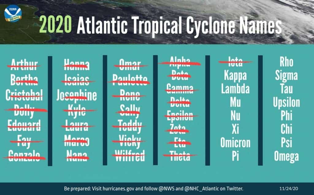
The predictions expected 13 to 19 storms to be named, with 6 to 10 that could become hurricanes (usually, the World Meteorological Organization (WMO) chooses 12 names per season). When the season started, the predictions seemed correct — a slightly above normal hurricane season. But things quickly started to change.
To the surprise of everyone, it wasn’t long before we reached a point where there were no more new names for storms.

Tropical Storm Arthur was the first to form on May 16th and lasted until May 19th. Eight days later another tropical storm was formed and the list continued until the last name, Wilfred, on September 13th. From that point, the WMO had to add more names to the list. To do so, the Hurricane Committee decided to use the Greek alphabet to complete the list until the letter ‘Iota’.
The last time something like this has ever happened was during the 2005 season, the season of devastating hurricanes like Katrina and Rita. This year 30 storms were active in the Atlantic Ocean, 2 more than the previous record. Of those storms, 16 were tropical storms and 5 were category 4 hurricanes.
It’s not just the number of storms, its intensity was also pretty scary. During this season, there were four simultaneous events, at least 2 storms happening at the same time. Laura and Marco, both hurricanes, started together and continued staying active almost at the same time. Laura was the strongest storm to hit Louisiana in the US.
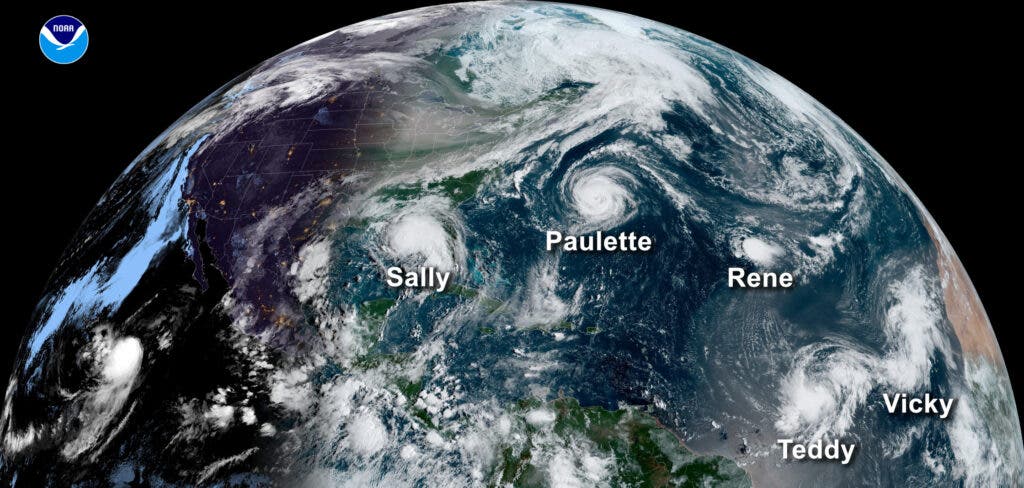
However, the most shocking view happened on September 14th when 5 storms were seen simultaneously: Tropical storm Sally, hurricane Paulette, tropical depression Rene, tropical Storm Teddy and the 21st storm that later was named Vicky, as seen in the first image.
The whole picture can be seen in a time-lapse of the entire season.
Warmer than average SST could very well be linked to climate change. More investigation of the conditions that caused such an intense period is required before drawing any firm conclusions, but even without a thorough analysis, we already know that climate change is causing more intense hurricane seasons. The hurricanes are also taking an increasingly large toll. Hurricane Eta, category 4, caused more than 200 fatalities.
Central America suffered severe impacts since Eta came just after a previous hurricane. Indigenous communities in Honduras faced harder challenges, not just losing their homes but also having to move to over-crowded shelters in the middle of the pandemic. This is a terrible consequence of climate-related disasters, the poorest communities are the main victims, especially the ones that least impact the climate.


