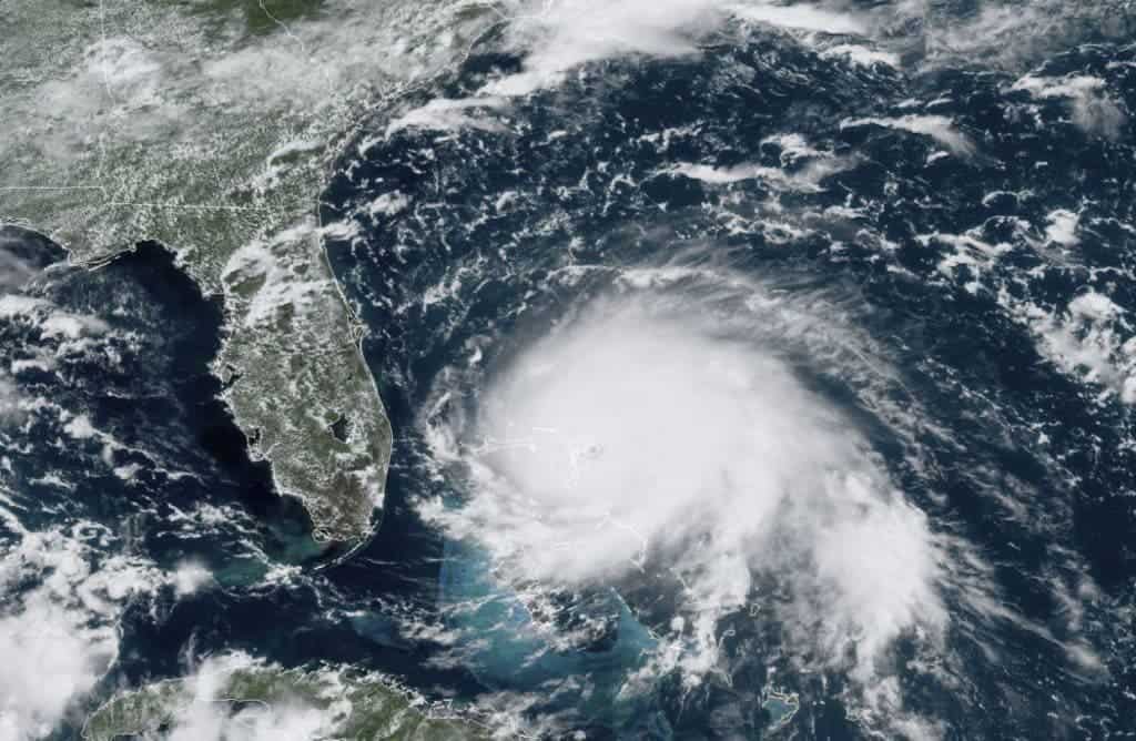
Described as the strongest storm so far this year, hurricane Dorian is causing catastrophic damage as it makes its way across the Bahamas. The storm has already claimed at least one life and is expected to begin trudging toward the mainland US later in the day.

The Category 5 storm made landfall on the eastern end of Grand Bahama Island Sunday night and will continue to pound the island for most of Monday as it creeps toward the southeastern US coast.
The death of an 8-year-old boy is being reported by local media outlets. The boy’s grandmother, Ingrid McIntosh, said that her grandson died on Abaco island. She said her 31-year-old daughter found the body of her son, who she believed drowned in the rising waters.
The storm had winds of 165 mph while it was 115 miles east of West Palm Beach early Monday. It will get close to Florida’s east coast Monday night through Wednesday evening. But the state has already begun to feel Dorian’s effects, as wind picked up throughout the day.
As it pummeled islands in the Bahamas, the hurricane left behind “catastrophic damage,” Hope Town Volunteer Fire & Rescue said. The damage was reported in Elbow Cay, Man-o-War and Marsh Harbour in the Abaco Islands, where buildings were destroyed and many were partially submerged, with water flooding all around them.
The Abaco Islands are a group of islands and barrier cays in the northern Bahamas, east of southern Florida. Dorian made landfall there as a Category 5 hurricane just after noon Sunday. The northwestern Bahamas will be drenched in up to 24 inches of rain, with some areas expecting up to 30 inches of water, the hurricane center said.
The terrifying storm could be making its way toward the East Coast of the United States, but it’s still unclear if Dorian will make landfall and where on the mainland US. The hurricane’s forecasted track shifted east Friday, making a Florida landfall less likely, but not impossible.
Models now show the storm skirting along Florida’s coast Tuesday and then next to Georgia late Tuesday and into Wednesday. But just because the center of the storm may not hit land doesn’t mean there won’t be damage. Early Monday, hurricane-force winds from the storm extended outward up to 45 miles.
Heavy rains and life-threatening floods are expected in parts of the southeast and lower mid-Atlantic US later this week. The storm will dump up to 6 inches of rain in Florida through Georgia. A coastal flood advisory was issued early Monday for South Carolina and Georgia by the National Weather Service, which warned of a high rip current.
Evacuation orders were in place for 13 Florida counties as of Monday morning, according to the Florida Division of Emergency Management. The agency urged residents who were in areas not under mandatory evacuations to “plan for adequate supplies in case you lose power & water for several days.”
“To see a catastrophic Category 5 hurricane closing in our 3rd most populous state is wildly unnerving,” FEMA Strategic Planner Michael Lowry said on Twitter. “Dorian is already a disaster for so many tonight. Please, please heed the warnings of local officials in the hours ahead.”
More than 900 flights were canceled going in and out of Florida airports, according to data from Flightaware.com. The Orlando Melbourne International Airport and Fort Lauderdale-Hollywood International Airport will suspend commercial flights and close terminals at noon Monday.
In Georgia, Gov. Brian Kemp ordered mandatory evacuations Sunday night across six coastal counties east of Interstate 95. Possible downed trees, power lines, debris and flooding as well as roads and bridges possibly becoming impassable were reasons behind the evacuations, the order said.
South Carolina Gov. Henry McMaster also ordered the evacuation of coastal South Carolina residents starting at noon on Monday. Christy Hall, the secretary of South Carolina’s Department of Transportation, said the agency has more than 2,200 employees working on hurricane plans.


